Photos

|
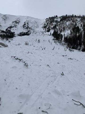
Out of Advisory Area, 2025-02-18 From obs" "Observed a few old avalanches today, maybe from the 2/8 storm. Although well out of the advisory area, helpful for skiers in the Red Lodge Area. 1) Silver Falls Cr (Lake Fork), 9200', E, HS-N-R4-D1.5-O 45cm thick pencil hardness slab, HS 135. Pulled out into upper 20 degree terrain. 2-3 avalanches here, with one crown ~600' long. 2) Misery Bowl (Main Fork), 9400', ESE, HS-N-R2-D2.5-O A few avalanches here similar to above, with one significantly larger avalanche appearing to have failed on depth hoar where the bowl tips South. 2-4' crown, ran about 600' vertical."
|

|
Northern Madison, 2025-02-18 Cracking in the new and wind-drifted snow on the Ridge of Middle Basin. These resulted in a narrow avalanche that ran quite far. Link to Avalanche Details |

|
Bridger Range, 2025-02-18 Skiers saw three natural slides south of the throne today. All east facing. Photo: I Freeland Link to Avalanche Details |

|
Bridger Range, 2025-02-18 Skiers saw three natural slides south of the throne today. All east facing. Photo: I Freeland Link to Avalanche Details |

|
Bridger Range, 2025-02-18 Skiers saw three natural slides south of the throne today. All east facing. Photo: I Freeland Link to Avalanche Details |

|
Cooke City, 2025-02-17 Skier in Republic Creek observed a natural (wind/storm slab) avalanche on an east aspect at ~9200ft. Photo: R. Minton Link to Avalanche Details |

|
Northern Madison, 2025-02-16 Photo: GNFAC |

|
Northern Gallatin, 2025-02-16 |

|
Northern Gallatin, 2025-02-16 Storm slab avalanche between Blackmore and Elephant. Photo: Anonymous Link to Avalanche Details |

|
Northern Gallatin, 2025-02-16 |

|
Cooke City, 2025-02-16 I could visibly see some layer distinction about 8-12” deep. This is the same weakish layer we found in our column test, where we got ect16 just below robs knob. This was on a north facing aspect. Photo: I Tuttle |

|
Northern Madison, 2025-02-15 Buck Ridge, snowmobile triggered avalanche. Propagated in the storm slab. Photo: C Erhard Link to Avalanche Details |

|
Cooke City, 2025-02-15 In Hayden Creek, we saw many D1-D1.5 wind slab avalanches seen on leeward slopes- east and northeast slopes at and above treeline. Photo: N. Mattes (Beartooth Powder Guides) Link to Avalanche Details |

|
Cooke City, 2025-02-15 In Hayden Creek, we saw many D1-D1.5 wind slab avalanches seen on leeward slopes- east and northeast slopes at and above treeline. Photo: N. Mattes (Beartooth Powder Guides) Link to Avalanche Details |

|
Cooke City, 2025-02-15 In Hayden Creek, we saw many D1-D1.5 wind slab avalanches seen on leeward slopes- east and northeast slopes at and above treeline. Photo: N. Mattes (Beartooth Powder Guides) Link to Avalanche Details |

|
Cooke City, 2025-02-15 In Hayden Creek, we saw many D1-D1.5 wind slab avalanches seen on leeward slopes- east and northeast slopes at and above treeline. Photo: N. Mattes (Beartooth Powder Guides) Link to Avalanche Details |

|
, 2025-02-14 Toured up around Blackmore and s cottonwood. Found an extremely reactive windslab in the afternoon. Photo: J Alford Link to Avalanche Details |

|
, 2025-02-14 Toured up around Blackmore and s cottonwood. Found an extremely reactive windslab in the afternoon. Photo: J Alford Link to Avalanche Details |

|
Southern Madison, 2025-02-14 Taylor Fork, Feb 13. Photo: GNFAC |

|
Southern Madison, 2025-02-14 We rode into the Taylor Fork on Feb 13, down into the bottom of Sunlight Basin, across Carrot Basin and to the Wilderness Boundary. We saw four persistent slab avalanches that likely broke last weekend or at the beginning of the week. All appeared to be snowmobiler-triggered R1-2, D1.5-2 avalanches at broke of the January layer of near-surface facets and surface hoar. Additionally, we saw one wind slab avalanche (R1, D1) in Sunlight Basin. This slide was fresh from this morning or yesterday. Photo: GNFAC Link to Avalanche Details |
