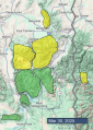
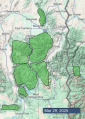
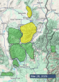
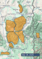
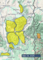
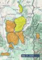
Advisory Archive
Snow totals since yesterday morning are:
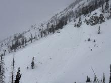
- 11” (0.9” snow water equivalent (SWE)) in Hyalite.
- 3-7” (0.3-0.6” SWE) in Big Sky, Cooke City and the Bridger Range.
- 0-1” (0.1” SWE) near West Yellowstone and Island Park.
Temperatures are teens to 20s F. Wind out of the south and east increased overnight to 10-25 mph with gusts of 25-35 mph, and this morning wind has lessened to 5-15 mph out of the southeast and southwest.
Today temperatures will reach high 20s and low 30s F. Wind will be calm to light out of the east, southeast and southwest. Snow showers through tonight should drop 2-3” in most areas with 4-7” possible near Cooke City, Hyalite and Big Sky.

Temperatures are below freezing across the whole advisory area for the first time since Monday. There are 2” of new snow in the Bridger Range and a dusting to an inch elsewhere. Winds picked up yesterday afternoon near West Yellowstone and Island Park, gusting 40-55 mph. Winds died down in those areas overnight and are now blowing 5-15 mph out of the west and south across the region.
Winds today will be light. High temperatures will be substantially cooler than the last couple days, generally in the 30s F. Around Bozeman and Big Sky, skies will be mostly cloudy and snow showers will leave 1-3” by this evening. Near West Yellowstone, Island Park, and Cooke City, expect a mix of sun and clouds, with only a dusting of snowfall. By tomorrow morning, 2-4” will fall across much of the region, with potentially a few more inches in the Big Sky area.
Several more rounds of snowfall are expected in the coming days.
Temperatures this morning are up to 10 degrees cooler than yesterday morning, but still fairly warm, in the high 20s and 30s F. Winds are 15-25 mph out of the west, south, and southeast. Skies are mostly cloudy and there hasn’t been any precipitation yet.
The sun may come out for a bit this morning, but by this afternoon it’ll be cloudy across the whole area and a few snowflakes may fall (and maybe raindrops at lower elevations). High temperatures will be 5 to 10 degrees lower than yesterday, in the 30s and 40s F. Winds will remain moderate, mostly blowing out of the south and west.
A dusting up to an inch or two of new snow may accumulate overnight. Temperatures will be much cooler tomorrow, with more substantial snowfall starting tomorrow night.

Enjoy the warmth and sunshine for one more morning as the weather pattern will turn back to winter tonight. The jet stream will generally stay to the south of us with cold air and multiple disturbances passing through for the next week or two. By this time next week there could be a decent amount of fresh snow in the mountains.
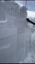
This morning air temperatures are in the mid to upper 30s F, about 4-5 degrees warmer than yesterday morning. Clear skies have likely cooled the snowpack on open slopes enough to refreeze and form a thin ice crust except on slopes in thick trees. Winds this morning are averaging about 15 mph and gusting up to 34 mph from the SW (a bit lighter in the Bridgers).
Today will kick off warm and sunny with rapidly warming temperatures reaching the low 40s F. Cloudy skies this afternoon and winds blowing 15-20 mph should put the brakes on warming. By the end of the day a few raindrops or snowflakes could fall as well as a rumble or two of thunder.

This morning, temperatures are in the upper 20s to low 30s F with 5-15 mph wind from the northwest to southwest. There is no new snow.
Today will be similar to yesterday, but warmer and sunnier, with high temperatures in the upper 40s to upper 50s F. Winds will be 5-15 mph from the south and southwest under sunny skies.

This morning, temperatures are in the high 20s to low 30s F with 10-20 mph winds from the west and northwest. In the last 24 hours, an inch of snow fell in the mountains around Cooke City, with some rain around West Yellowstone and Island Park.
Today, high temperatures will be in the 40s to 50s F with 5-15 mph winds from the west and southwest. Skies will be mostly sunny across much of the forecast area except Cooke City, where overcast skies may produce a few showers.


Since yesterday morning 24 hour snow totals are:
- 5”+ near Cooke City.
- 3” near West Yellowstone.
- 1-2” in Island Park, Big Sky and Bridgers.
- Zero in Hyalite.
Wind has been westerly at 15-35 mph with gusts of 40-60 mph overnight. Temperatures are high 20s and low 30s F.
Today, under mostly cloudy skies, temperatures will reach high 30s and low 40s F, and wind will be from the west at 15-30 mph with some stronger gusts. There is a chance for snow showers and possibly rain this afternoon and evening. The mountains could receive a trace to an inch of snow by morning.


Since yesterday morning 24 hour snow totals are:
- 4-6” around Big Sky.
- 3” in Island Park, West Yellowstone and Cooke City.
- 2” near Bozeman.
- 1” in Taylor Fork.
Yesterday the wind was 15-25 mph with gusts of 45-55 mph. This morning, temperatures are single digits to teens F, and wind is from the west and northwest at 10-15 mph with gusts of 20-35 mph.
Today, temperatures will reach high 20s to low 30s F, and wind will be from the west and northwest at 10-30 mph. Snow showers this afternoon and tonight could drop 5” or more near Cooke City with 1-3” elsewhere by morning.

24 Hour Snow Totals:
- 4-5” around Cooke City, Island Park, and West Yellowstone (including the S. Gallatin and S. Madison Ranges).
- Trace around Bozeman and Big Sky.
This morning, temperatures are in the teens and 20s F with 15-35 mph winds from the southwest and west. Snow is falling across much of the forecast area, with higher precipitation rates farther south around Island Park, West Yellowstone and Cooke City.
Today, high temperatures will be in the 20s to low 30s F, with strong winds this morning blowing 20-40 mph from the west and southwest. By tomorrow morning, the mountains around Cooke City, Island Park and West Yellowstone will receive 3-5 inches of new snow, with 1-3 inches near Bozeman and Big Sky.


This morning, new snow totals are:
5-8” near Big Sky
3-4” near West Yellowstone, Island Park and Cooke City
1-2” near Bozeman
Winds peaked yesterday evening, gusting 45-60 mph out of the west. They have backed off a little bit this morning, to 15-20 mph, gusting into the 30s and 40s mph. Temperatures are in the teens and 20s F.
Today, westerly winds will pick up again, blowing consistently in the 20s and 30s mph, with gusts into the 40s and 50s mph. High temperatures will be in the 20s and 30s F. We’ll see a mix of sun, clouds, and snow showers today before accumulating snow moves into the area tonight. By tomorrow morning, expect 4-8” around Island Park, 1-3” near West Yellowstone, Big Sky, and Cooke City, and only a dusting near Bozeman.