Snow Observations List
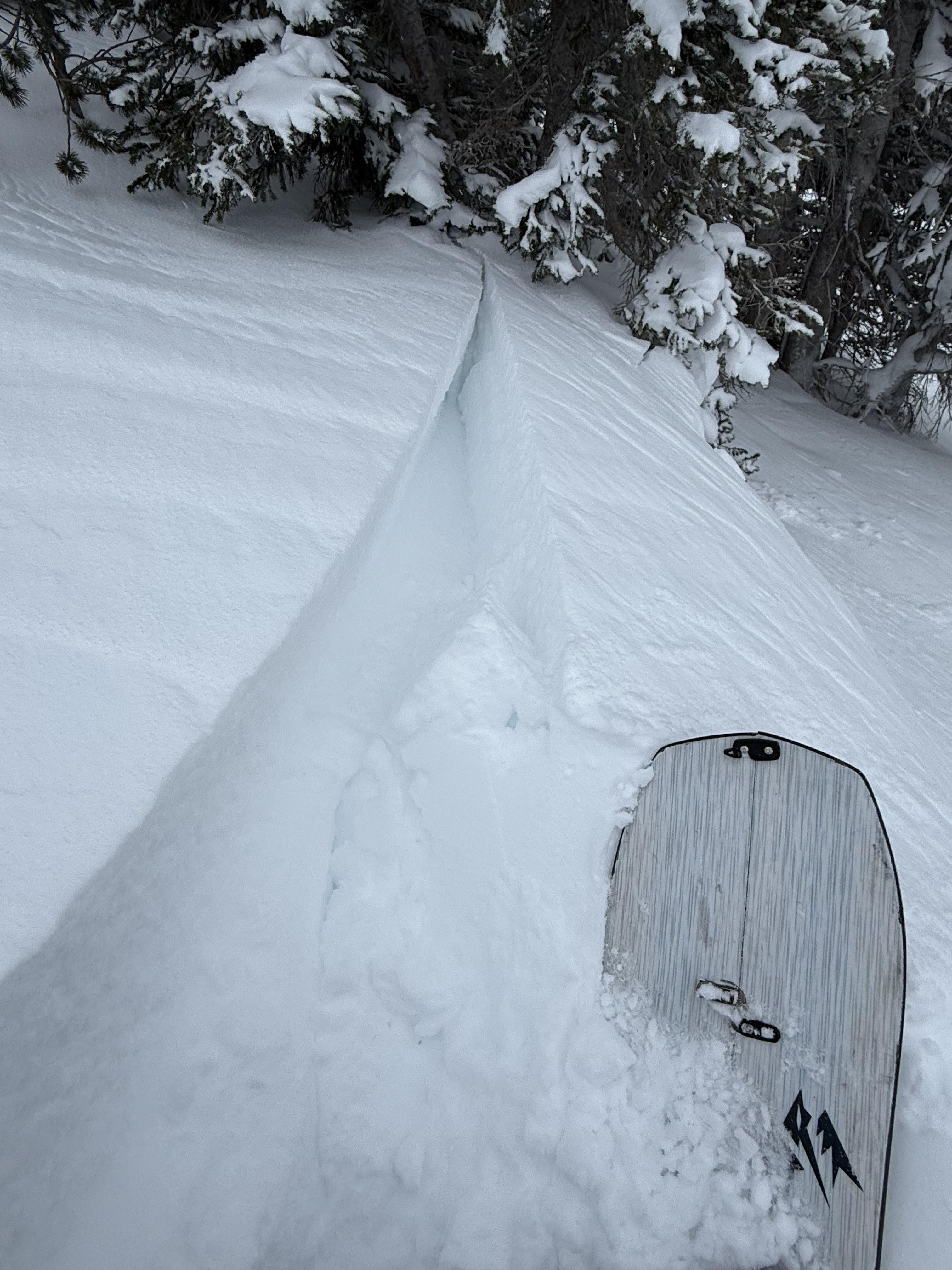
Lots of wind slabs south of Cooke today. Strong wind all day and lots of blowing snow.
Full Snow Observation ReportFrom FB messenger: “Bottom of Slats area. Buck ridge.
NE slope/hole wind loaded. Sled triggered, 315 pm Sunday Dec 15, 2024”
Rode along Buck Ridge, through 1st, 2nd, and 3rd Yellowmules, with good views across Buck Creek and into McAtee Basin. New snow depth increased as we rode from the parking lot to the top of Beaver Creek, from ~4" to 12". We measured 12" of new snow with 0.7" SWE in 1st Yellowmule. We saw two avalanches. One was a storm slab avalanche on the far (southwest) side of Buck Creek - broke 2-300 ft wide and ran ~500 vertical feet. The other was a smaller slide in 3rd Yellowmule (~100 ft wide and ran ~200 vertical ft). There was not much wind effect.
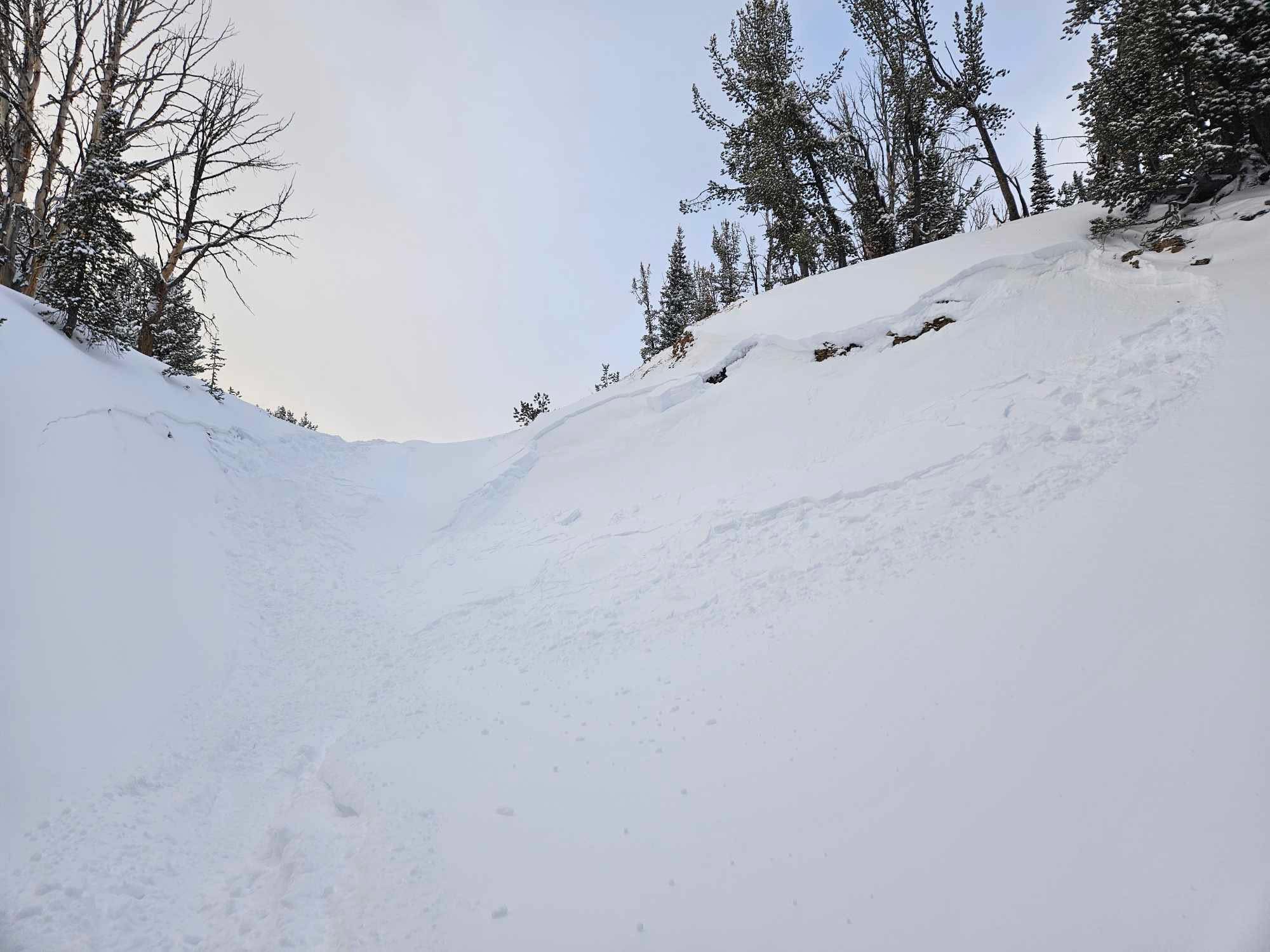
We crossed through the head of McAtee Basin into upper Bear Creek. While riding on a low angle ridgeline, we remotely triggered a slide that broke approximately 200 ft away in a gully. It failed ~18" deep on facets underneath the snow that has accumulated since Sunday. It broke in several pockets, totaling around 200 ft wide. There was 12" of new snow at the crown, with 0.7" SWE. The slab contained 1.4" SWE total (which accumulated since Sunday).
Before triggering the slide we experienced no cracking, collapsing, or other clear signs of instability.
Full Snow Observation ReportCONSIDERABLE seemed right for today. Keeping it at CONSIDERABLE for tomorrow seems good.
Dug a pit on the east facing slope around 7800'. The snow was 60 cm deep. We got ECTN11 and CT12 RP 15cm down on the old/new snow interface, ECTN16 25cm and CT19 25cm down on a crust.
Also dug a hand pit on a south slope at 6800' to test the new snow and it didn't break easily or cleanly.
We didn't observe any whumphing or cracking.
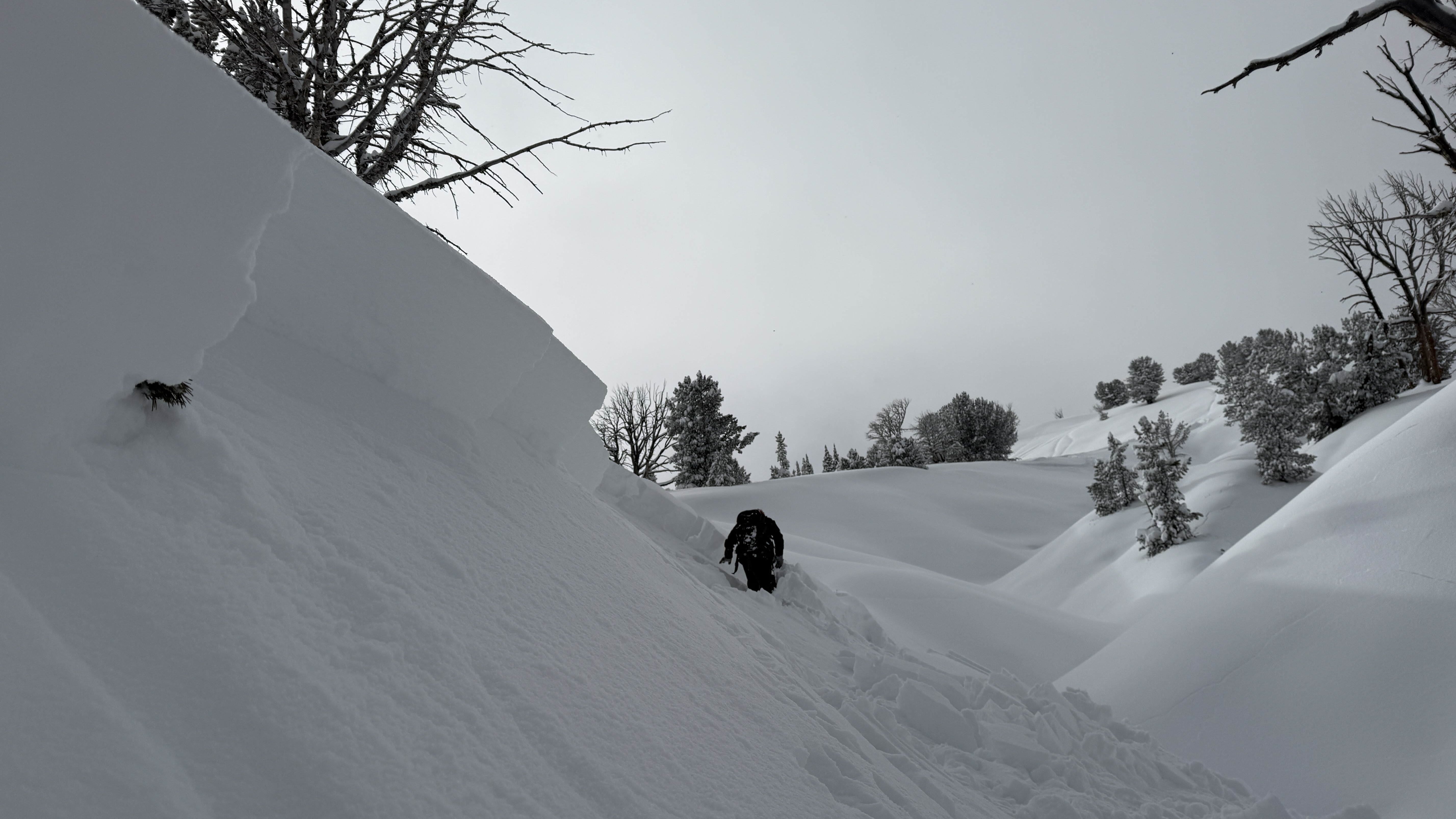
Full Snow Observation ReportTriggered a small slide (r2 d2) in a north east facing chute at around 8300 ft. The slide was triggered on a ski cut through a wind loaded drift and propagated about 15 or 20 ft wide. It about 6 in deep on the edges and two feet in the loaded area. We observed several other signs of instability throughout the day, most wind loaded terrain was touchy and easy to rip off with slabs anywhere from 6 in deep to two or three feet deep. All signs of instability originated from the interface between the new snow from the last few days and facets from the last high pressure system.
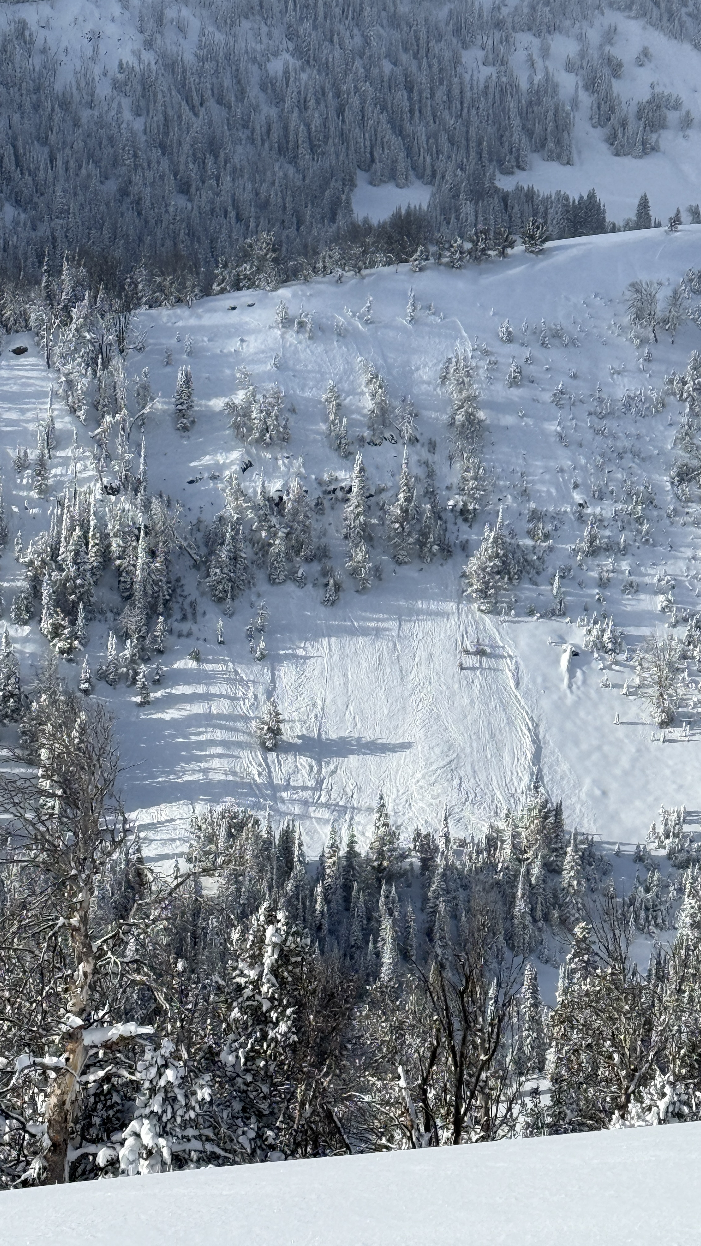
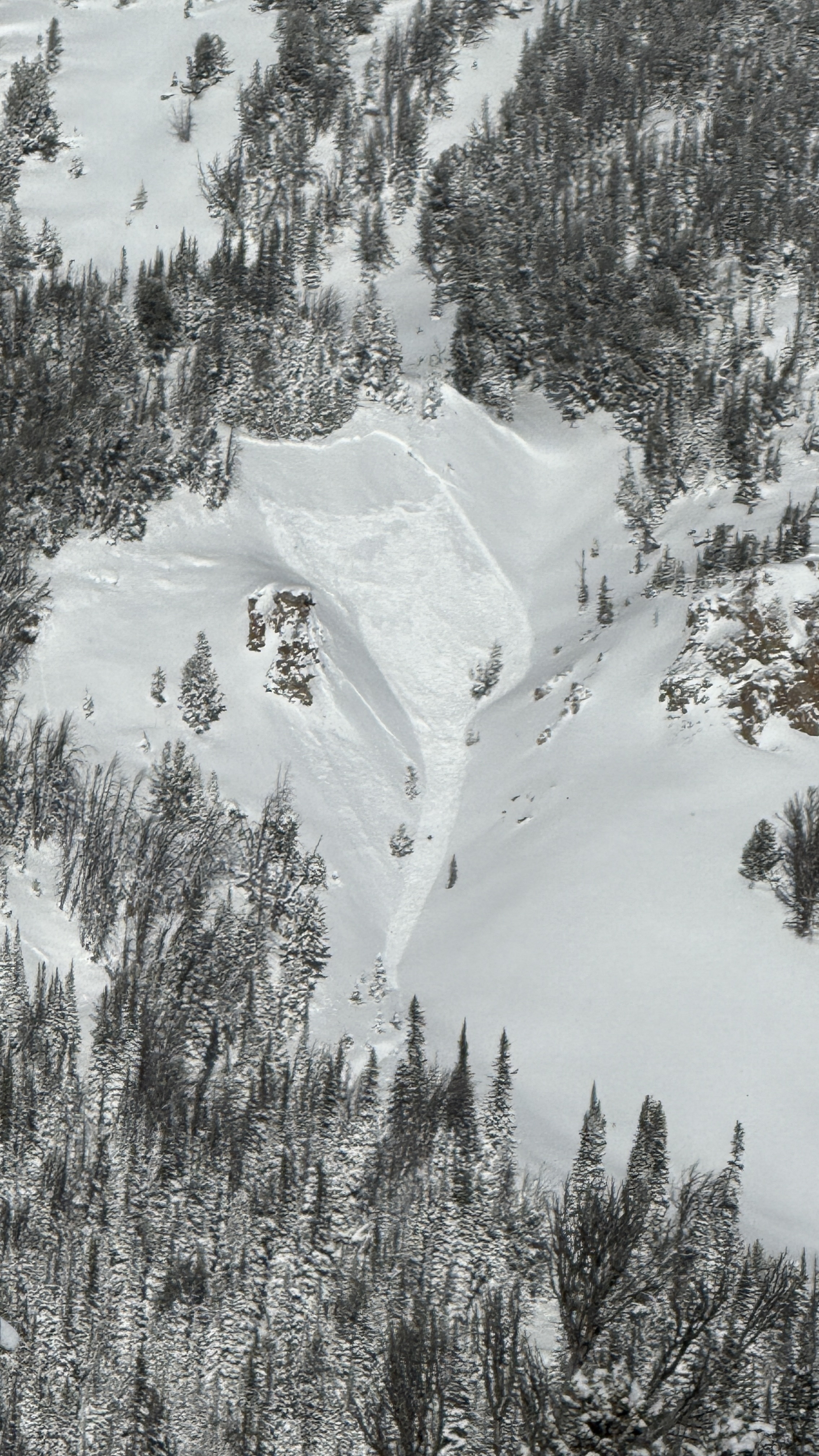
Full Snow Observation ReportThe clouds broke briefly around noon today in Cooke City. It looks like the Fin slide naturally in the past day or so. It looks like two sections of the face slid, one from the top, and one lower and to the right in the photo.
Full Snow Observation ReportThe old snow surface from the first two weeks of dry weather in December is the main weak layer in the snowpack. It is easy to find on all slopes just under the new snow and two crusts. It's generally buried about a 12-14 inches deep.
We got a range of test scores (mostly bad) of ECTP2, ECTP3, ECTP13, and ECTN. We experienced a few collapses, but it was not widespread. No cracking.
Avalanches - we got above the clouds into the sun and could only spot one avalanche looking towards Mt Jefferson in Rock Creek
My gut says that avalanches aren't too easy to trigger; HOWEVER, all the signs are there and can't be ignored. Some collapsing. A prominent weak layer of facets. Mostly poor test scores, recent loading (1.5-2" of water), and one fresh avalanche.
For those reasons we rode like the danger was CONSIDERABLE....which it was.
Riding and coverage is quickly improving. Above 9000 ft, there's a decent base under the weak layer. Rocks and stumps are still easy to find and we were bumping them all day long.
Full Snow Observation ReportAround 5" of fresh snow lay on top of the snowmobiles this morning in Cooke City. We rode up to Daisy Pass to visualize terrain and got eyes on Crown Butte. On the north side, we noted the crown of a wind slab avalanche (R1 D1) that broke during the storm cycle. We then rode back down and toured up Henderson Mountain along its SW flank. Skies cleared throughout the day and allowed for great visualization of terrain north of Cooke. We got eyes on Miller Ridge, Crown Butte, Henderson Bench, Scotch Bonnet and Sheep Mountain; we did not note any other avalanches outside of the small one up on Crown Butte. We saw extensive cross-loading in the bowl of Henderson Mountain and on Miller Ridge.
We dug snowpits on SW and S aspects on Henderson. We noted buried facets a little over a foot deep on our pit on the SW and we got an unstable test result in our snowpit on the S aspect (ECTP 25) on a facet/melt freeze crust sandwich.
Most notably, as we entered non wind-effected, upper-elevation terrain on Henderson, we consistently triggered many localized collapses and heard audible whumpfs, indicating persistent slab instability.
Full Snow Observation ReportIn the absence of additional information or loading, it feels reasonable to drop to CONSIDERABLE on wind-loaded, and MODERATE on non-wind-loaded slopes. Moderate confidence in this with a low threshold to hold full CONSIDERABLE.
These avalanches were reported yesterday 12/15 by ski patrol who heard them run and saw debris around 1230. They broke naturally towards the end of a period of heavy snowfall that totaled 10"=1.22" SWE. Photos taken 12/16 at 1045-1100.
Full Snow Observation ReportToday, we rode up to the base of Henderson and toured up to the bench to check out the crown of an avalanche that occurred yesterday. The avalanche was remotely triggered by a skier from 50' away. It was about 100' wide, ran 50' vertical, and the max depth of the crown was 2.5'. It fractured on the interface between the new storm snow and faceted grains. This was a heavily wind loaded area with an HS of 179cm. Strong westerly gusts and heavy snowfall had nearly refilled the crown by the time we left.
We then traveled further up the bench to a north facing aspect and dug again. Here we got an unstable test result, ECTP 13, on a layer of buried surface hoar. Faceted snow exists at the base of the snowpack but our main concern on non-wind loaded slopes is layers of surface hoar and near-surface facets buried about 50cm deep. It was snowing and blowing throughout the day, and with continued loading, we expect to see collapsing, cracking and signs of instability tomorrow.
Full Snow Observation ReportDug on a NE aspect on The Ramp at about 8500’. HS was around 100 cm but varied quite a bit. There’s a layer of very weak facets about 40cm down from the surface that are particularly concerning to me. The storm slab I observed yesterday is also still quite reactive, but the snowpack seems to still lack a significant slab on the aspects where I’ve been traveling. There was an abundant amount of cracking in the newer snow whenever traveling off a beaten path. In our pit, got results of CT3 SC and CT7 SC on the storm slab fracturing at the interface with sudden collapse character. The layer of facets farther down in the snowpack collapsed at CT10 SC. I also performed a PST on the weak layer of facets and the weak layer probated to end at 35/100 cm.
Full Snow Observation ReportWent out north of Cooke City today for some skiing. Dug a pit at 9980' on a southwest facing, windloaded slope with a slope angle of about 15 degrees. We found 105cm of snow. Our ECT gave us an ECTP29 55cm up from the ground on what seemed to be the buried surface hoar layer. It was snowing and blowing all day out there.
Full Snow Observation ReportFrom email: "Steve Harvey and I did a quick pit yesterday (12/16/2024) S. of Cooke in Republic Creek. E. aspect; 9.085'; 30° slope; HS 80 c; 12:30PM, Calm/cool (teens), Lt snow.
ECTN21; ECTP24 at 50 cm on buried facets. We declined to continue on slope.
We didn't perform a detailed profile, but generally, fist (new snow) and 4-finger above buried facets and progressively 2-finger to 1-finger below.
Noticeable Issues:
(1) Low and variable snowpack, 30cm or less under/near trees and on wind-scoured aspects and loading in fetch zones. Something to keep in mind as season progresses with potential sweet spots in predictable places.
(2) Buried 50 cm facets/hoar that is essentially everywhere in Cooke City zone.
(3) We did not observe buried deep facets at the base of the snowpack."
Full Snow Observation Report
Skied Bacon Rind meadows today. Didn't look at the Skillet.
S1-S2 all day, L-M winds from the south
HS of 45cm at the road and 65cm at the ridgeline. It is more or less entirely faceted and unsupportable. Ski pen of 40cm and boot pen to the ground.
Skiing was good but hazardous. Lots of audible rock strikes, and getting through the trees back to the road was challenging.
Not recommended yet.
Full Snow Observation Report
Came across small debris pile while setting a skin track up to Texas Meadows from Bradley Meadow/Wolverine area. No other signs of instability. Texas Meadows showed facets down low and wind slab above.
Full Snow Observation ReportHeaded up Blackmore Sunday 12/15, late morning, was pleasantly surprised by the amount of new snow. Not sure how much was brand new, but up below the summit seemed like about a foot of fresh. Skinned to the ridge above the east face, plenty of wind at the ridge, dug a out on the east slope just below the ridge a bit north of where most people ski down in snow that was not wind affected. Isolated column test clearly showed a weak bond between new snow and old, decisive ECT-P 5 on the extended column test. Skied the trees out.
Full Snow Observation ReportOn our first column test was CTX and slid on the saw cut, in the video we didn’t get the same result but still very reactive.
During our extended column test we were at 9500ft on a North slope.
ECTN second tap storm slab
ECTN twenty three on ground facets
Full Snow Observation Reportfrom @brendan_durrum_photo
Full Snow Observation ReportFrom IG: "Storm slab broke about 200’ above us as skinning up the hallway coming from the north side on the throne."
Full Snow Observation ReportFrom IG… “Please don’t tag me if anything. Thanks”

